
The City of Amsterdam is facing the huge task of assessing and potentially replacing 200 km of the quay walls along its charming old inner-city canals. Adjacent historical buildings are often susceptible to damage by nearby construction activities. Satellite InSAR is being used to monitor areas across the city. Monitoring subsidence is seen as a vital tool in the efforts to preserve the physical charm and historical assets of this scenery.
Deltares, the City of Amsterdam, TU Delft, and SkyGeo have published an article on the reliability of PS-INSAR usage compared to regular ground levelling and general InSAR data. It describes how the PS-InSAR process can considerably reduce the current lengthy period required for levelling updates and verifies the improvement in reliability when using a locally optimised SkyGeo InSAR dataset.
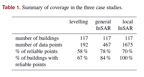
The City of Amsterdam started innovating by using levelling techniques centuries ago, when they introduced the NAP (National Reference Height). They have been measuring and placing markers on buildings throughout the city to aid in the assessment of subsidence. This is a profound effort as the inner-city is completely built on soft soil. Levelling and InSAR data usage are both used across the city to provide valuable insights on deformation. A direct comparison between levelling and satellite measurements means little, but researchers found a specific statistical procedure that is applied to levelling and satellite measurements to verify their reliability and determine the rate of vertical deformation of the buildings.
Conclusion of the PS -InSAR study
There is merit in the insight building fine-tuning of local datasets. Caution should be considered with generic, publicly available, InSAR datasets. All three case studies showed deformation rates of the satellite measurements are significantly higher than those of the levelling on the same buildings. Locally optimised PS-InSAR satellite measurements are most suitable for assessing the deformation rate of buildings in the Amsterdam inner-city.
PS-InSAR is available for Geomotion customers looking to scale trust with InSAR data.
Article courtesy of SkyGeo
